Conejo Canyons Moderate Hike – Rancho Conejo Blvd to Elliott Mountain
Conejo Canyons Moderate Hike – Rancho Conejo Blvd to Elliott Mountain
This moderately strenuous hike is 5 miles long with about 1150′ of climbing. It starts at the west end of Rancho Conejo Blvd, drops into Hill Canyon, then climbs to the top of Elliott Mountain overlooking the Western Plateau, Hill Canyon and Lizard Rock.
From the north/west end of Rancho Conejo Blvd, take Hill Canyon Fire Road (formerly known as “Baxter Fire Road”) northeast and down. About 0.4 miles along, turn left onto the easy-to-miss unnamed trail (also known as the “Baxter Trail”) to Hill Canyon Trail at the bottom. Turn left and after 300 yards, turn left again and head up the Western Plateau Edison Rd. After 0.6 miles, turn right and follow the unnamed trail (known locally as the “Outlaw Trail”) around to the right (southeast), soon bending north. After a mile, the route turns right onto the Elliott Mountain trail, but about a third of the way up you may want to take the short trail to an overlook of Hill Canyon for a break. The Elliott Mountain Trail continues the final 0.2 miles to the top. Return by retracing your steps. On the way back, the trail on the south side of the Western Plateau Edison Rd from the bottom of the Outlaw Trail leads about a hundred yards to an overlook of Hawk Canyon (pink on the map).
From the 101 Freeway in Newbury Park, take Exit 47 and drive north on Rancho Conejo Blvd and follow it for 2.2 miles to the end.
Map of This Hike
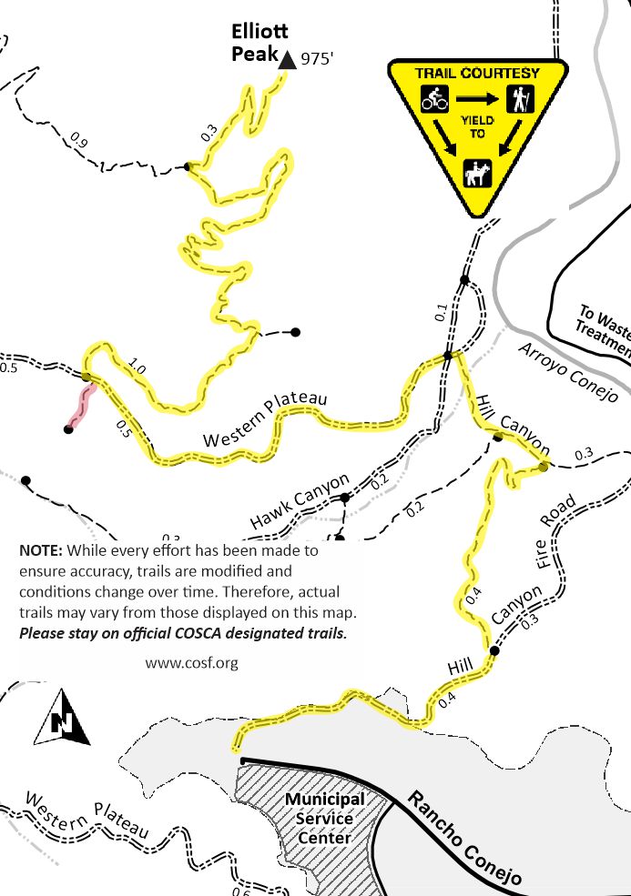
Note: Elliott Mountain was previously known as Elliott Peak.